Must-see places to visit in the Northern Territory.
Alice Springs

Alice Springs in the Red Centre is the second biggest town in the Northern Territory, after the capital, Darwin. The original Alice Spring, the permanent waterhole that became the key terminal for the Overland Telegraph Station in 1870, is still running, but the city that has grown around the well is now the vibrant hub of Central Australia. The restored buildings of the original repeater are preserved in a historic reserve 3 kilometres north of The Alice centre.
The city is the point from which the intrepid strike south for the Simpson Desert, east to the ghost towns of the MacDonnell Ranges from which the fossickers head, north for the gemfields from which tens of thousands of tourists bus or fly west to Australia's best-known icon, Uluru.
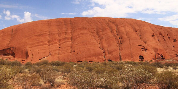
Known for many years by millions of tourists as Ayers Rock until Aborigines reclaimed The Rock and the timeless name, Uluru is the world’s largest monolith and stands 546 metres above the plain in the heart of the largest island continent. The road ringing Uluru gives a magnificent, three-dimensional view of the Rock and an appreciation of its awesome size. Alice's desert climate supports horticulture and grape industries worth $50 million annually.
It's a city where visitors not only come to prepare for sorties into the unique bush but to absorb the singular ambience. The Alice is also a major outlet for Aboriginal art, and contemporary paintings are exhibited in several galleries in the city.
Festivals - Alice is Wonderland (March), Country Music Festival (May), Finke Desert Race (June), Camel Cup (July), Henley-on-Todd Regatta (August), Corkwood Festival (November).
Daly Waters
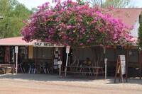
Daly Waters is 274 kilometres south of Katherine near the Stuart and Carpentaria Highways junction. Despite the tiny population of the settlement, the Daly Waters' Pub is one of the Territory's most famous watering holes. One of the oldest buildings in the Northern Territory, the pub is a quirky place clad in corrugated iron and crammed with decades of memorabilia.
The annual Daly Waters rodeo is an institution not to be missed. Daly Waters also has a rich and interesting aviation history, being the centre for the London to Sydney air race of 1926, a World War II air force base, and a refuelling stop for Qantas. The Daly Waters hangar exhibits interesting facts, photographs, and equipment from the area's former aviation glory days.
The Jingili people, the traditional Aboriginal owners of the area, believe the Dreaming tracks of the Emu and the Sun travelled through here on their way to the southern parts of the Northern Territory. In 1862, after two unsuccessful attempts to cross the continent, early explorer John McDougall Stuart finally discovered water in this region. He blazed an 'S' in a nearby tree to signify his important find.
Darwin
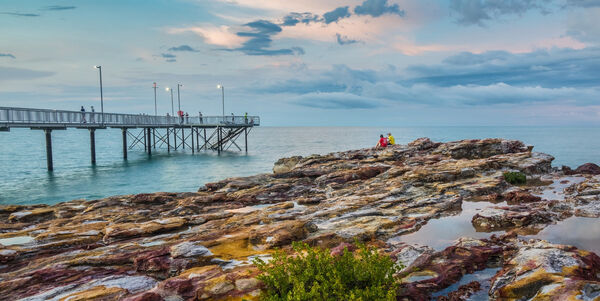
Darwin, Northern Territory’s tropical capital city is the first stop and gateway to the Top End. It offers all the sophistication of an international city with restaurants, hotels, museums, art galleries, and nightlife
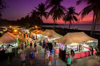
Its colourful history has contributed to Darwin’s cultural diversity with more than 50 nationalities including the area’s traditional landowners The Larrakia Aboriginal people.
The history of Darwin and the Top End is also on display with many historical reserves, museums and attractions charting the region's progress. From the pioneering days of early settlement, the mining boom times, the war years of WWII, and the impact of cyclones and the natural environment.
Enjoy discovering Darwin’s attractions on a city tour or why not take a sunset cruise on spectacular Darwin Harbour? Darwin is renowned for its world-class fishing, and the local waters are home to a vast array of tropical fish and the famous Barramundi.
On weekends you will find the city is scattered with open-air markets at Parap, Nightcliff and Mindil Beach. Discover locally made arts and crafts, performances from musicians and artists, a variety of street theatre, traditional bush poetry and even free stock-whip cracking lessons.
Kakadu National Park
Immerse yourself in World Heritage-listed Kakadu National Park, a natural and cultural wonder around three hours from Darwin. Discover detailed Aboriginal art galleries, hike to the top of rugged escarpments and cruise the wetlands past waterlilies, waterfalls, crocodiles and migratory birds.
Katherine
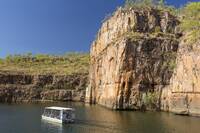
At the end of a 337km drive south from Darwin, Katherine is a large, well-presented town on the Katherine River.
Katherine was a vital staging post in the Top End defence in World War II and still plays an important role in the defence network as host to Tindall Air Force base.
Katherine is the centre of a large beef cattle region and an important gold producer. Tourism, too, is on the march as visitors are attracted by the spectacular river and Katherine Gorge.
Known as Nitmiluk to the local Aborigines, the gorge's ancient rock walls are pitted with caves and decorated with Aboriginal art which ranges from miniature paintings to large murals. The gorge is a sanctuary to 58 species of reptiles and amphibians, including freshwater crocodiles, and kangaroos and wallabies.
Generously supported by a vibrant, local art and craft community, Katherine has several galleries displaying a full range of materials from craftwork to traditional and contemporary Aboriginal paintings.
Kings Canyon
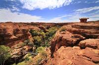
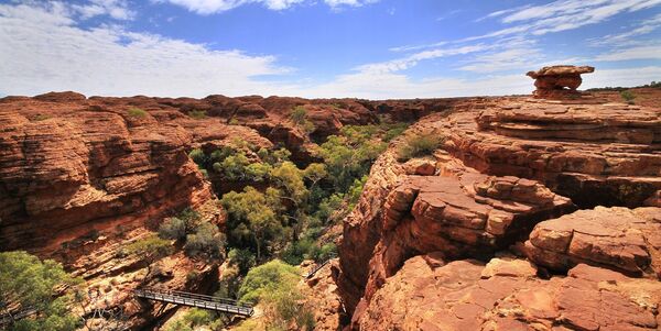
Kings Canyon, Watarrka National Park, is located 450 kilometres southwest of Alice Springs in the Uluru-Kata Tjuta region of the Northern Territory. The Park encompasses the western end of the George Gill Range and is home to various unique native flora and fauna, including over 600 different plant species. Commercial accommodation can be found within the Park at the Kings Canyon Resort and Kings Creek Station.
The area has also been home to Luritja Aboriginal people for the last 20,000 years. The word 'Watarrka' refers to the umbrella bush that proliferates in this amazing landscape. Combined with an eerie collection of weathered rock formations known as the Lost City and a permanent waterhole veiled by palms and ferns known as the Garden of Eden, a visit to the incredible Kings Canyon is full of surprises.
Kings Canyon has several accommodation options from campsites to luxury hotel units, a restaurant, cafe, bar, souvenir shop and fuel.
The 'Canyon Rim Walk' requires a reasonable fitness level as the initial ascent to the top can be demanding. The walk is approximately six kilometres so allow at least three hours, wear sturdy footwear, and appropriate clothing and carry at least one litre of water per person. The canyon can also be viewed via scenic helicopter flight out of the resort or Kings Creek Station.
Litchfield National Park
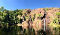
About 2 hours south of Darwin is Litchfield National Park with 15,000 square kilometres of weathered and ancient landscapes, magnetic termite mounds, warm year-round swimming in plunge pools, and delightful bush walks. It can be reached by taking the turn-off from the Stuart Highway to the township of Batchelor, the gateway to the National Park.
The Top End has two distinct seasons: the dry, cool season from May to October and the hot, wet season from November to April. The months of October and November are called the 'build-up' and are the hottest and driest times of the year. The drier times are better suited for a day trip from Darwin or an overnight camping expedition to the area.
Originally the home of the Wagait people, European expeditions were made into the wild countryside in search of minerals, until 1955 copper and tin were mined here before the land was turned over to pastoral leases, and in 1983, it was proclaimed a national park.
Scenic waterfalls with deep, crystal-clear plunge pools at their base are present year-round for pleasant swimming and camping. The most popular of these is Wangi Falls. Be aware that that there can be freshwater crocodiles, who are fortunately more bashful than their estuarine cousins. Forests around the falls are scored with short and longer bushwalking trails.
Weathered sandstone escarpments and black soil plains, dotted with fascinating magnetic termite mounds, contrast with patches of monsoonal rainforest. The remote locations such as Tjaynera Falls (Sandy Creek) and the ancient sandstone formations of "The Lost City" are accessible on four-wheel drive tracks.
Stop-off points with display boards are well-marked along the sealed network of roads through the park, making it easy to learn more about the history and ecology of this remarkable area.
Be sure to take plenty of water, sunscreen and insect repellent. Also, take care to read warning signs near swimming spots.
Mataranka
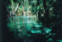
The Mataranka township, 100 kilometres south of Katherine on the Stuart Highway, was the setting of the famous Australian novel 'We of the Never Never' by Jeannie Gunn. Jeannie Gunn, "The Little Missus", lived at nearby Elsey Station, and her affection for the area has been immortalised in her book. Within Elsey National Park, you will find the grave of her husband and a memorial to the author at the Elsey Cemetery and Reserve. Elsey Station is now administered by the local Aboriginal people.
The ancient dreamtime stories of the Mangarayi and Yungman tribes describe a wind sweeping in from the east that created the area. The famous Mataranka Thermal Pool is a great place to unwind. The warm, crystalline waters of the natural pools can soothe aches and pains after a long day on the road. The water is spring fed, bubbling up at a fairly constant temperature of 34 degrees Celsius. The surrounding paperbark and palm forest filter the sun and leave soft, dappled light playing on the water's surface.
The area around the pools is a natural breeding ground for the little red flying fox, whose breeding season is usually from November to May but often extends into the drier months. During the breeding season, there are ranger-guided talks available. Bitter Springs, a short drive northeast of Mataranka, is a relaxing alternative to the main thermal pools. Take your goggles because small turtles and fish can often be spotted below the surface.
Tennant Creek
The old gold mining town of Tennant Creek is situated 500 kilometres north of Alice Springs. The town’s gold mining history remains and is captured at sites around the town such as the Battery Hill Mining Centre.
The rugged and beautiful landscape south of Tennant Creek is sweeping plains of golden grassland and is home to the Devil's Marbles. These huge granite boulders are scattered through a valley and glow a rich red in the early evening light.
Uluru
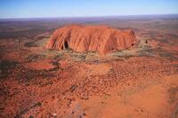
Remote, awesome, and splendid in colours that vary as the day unfolds from soft blue hues to glorious orange-reds, Uluru is one of the most magnificent sights in Australia. Located in the Red Centre, 450 kilometres from Alice Springs, visitors must travel to one of the most isolated pockets in the country. But the proof of its power is that people continue to come and be fascinated by this sandstone mountain that rises 348 metres above the surrounding plain.
Ernest Giles was the first European to name landmarks in the area in 1872. Describing the Olgas as 'monstrous pink haystacks', he named them after Queen Olga of Wurttemberg. Uluru, formerly known as Ayers Rock, was named by William Gosse after Sir Henry Ayers in 1873, then premier of South Australia (which administered the Northern Territory until 1911 when the Commonwealth took control). In 1987 the 126,000-hectare park was put on the World Heritage listing.
In 1985 management of Uluru and the surrounding Uluru National Park was handed back to traditional owners the Anangu people, who work in conjunction with the Australian National Parks and Wildlife Service. Part of the experience of travelling here is becoming acquainted with Aboriginal customs and beliefs and the sense of Aboriginal spirituality that envelopes the rock. Aboriginal guides lead tours around the base of the rock and explain the significance of features to their culture. For those exploring on their own, interpretative signs assist in gaining an understanding.
A walk around the approximately 9-kilometre base reveals caves, overhangs, and interestingly sculpted formations in the deeply eroded yet smooth rock face.
About 30 kilometres from Uluru are the almost as strange Kata Tjuta (formerly known as the Olgas), 36 separate domes of red-brown earth perched on the desert landscape. The name 'Kata Tjuta' means 'many heads', and another interesting walk around several of these domes takes you through the so-called Valley of the Winds. Mount Olga, the tallest of the Kata Tjuta domes is 200 metres taller than Uluru.
