
United Nations Educational, Scientific and Cultural Organisation or UNESCO as its more commonly known, is an agency that forms part of the United Nations with the aim of promoting buildings, complexes, manmade and natural environments and other destinations of educational, scientific, cultural and historical importance.
Founded in 1945, just after the war, the agency represents 193 member states. Its core goal is to advance peace, sustainable development and human rights by facilitating collaboration between nations.
Contents
Australia
Canada
New Zealand
USA
Southern Africa
Key
Name of UNESCO site (type, year added to list)
Location(s) [link to image credit]
⟁ Listed Historic Monument in host country
★ Listed Nature Reserve (Ramsar, Biosphere Reserves)
Australia
Australia; the sixth largest nation, the largest island and the smallest, flattest continent. Considering its vast size, its population is just 25 million, but despite this, it is home to 17 incredible UNESCO World Heritage Sites, a mix of cultural landmarks and natural wonders from Sydney's Opera House to the crown in its red centre; Uluru.
In this list, we've only included mainland sites or islands close to the mainland.
⟁ National Historic List: National Heritage List
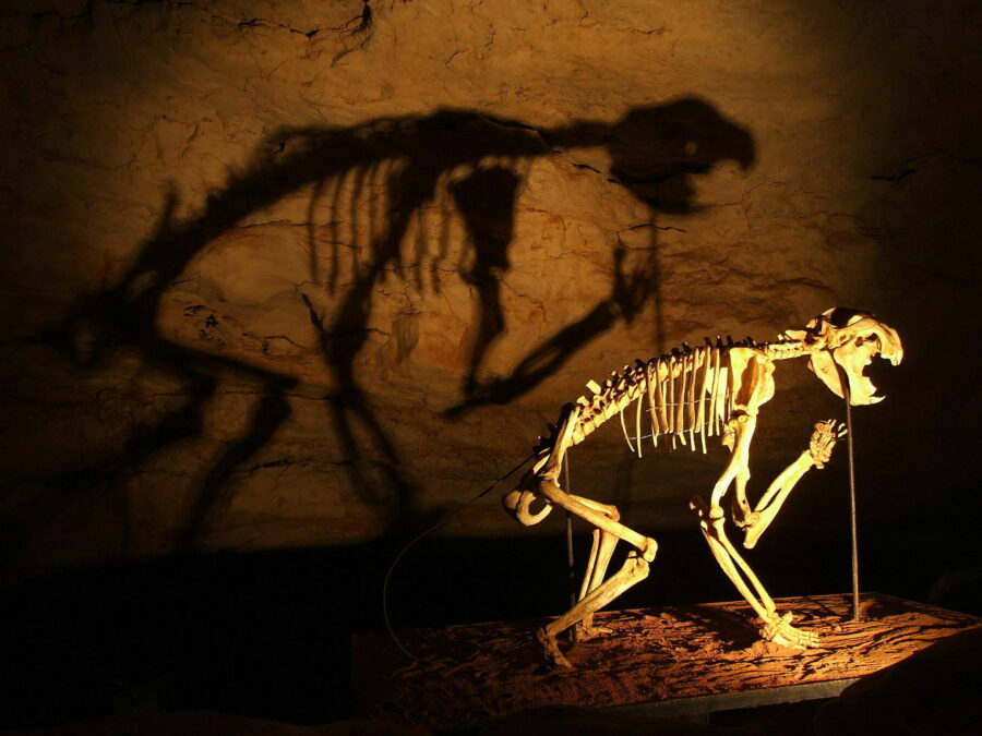
Australian Fossil Mammal Sites (natural, added 1992)
Queensland, South Australia [Naracoorte Caves National Park - Wikipedia]
Situated in Eastern Australia, in the north and south respectively, Riversleigh and Naracoorte are among the world's greatest fossil sites representing the key stages of evolution of Australia's unique fauna.
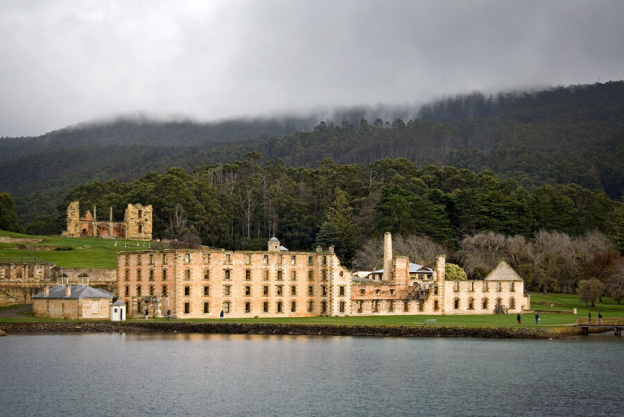
Australian Convict Sites (cultural, added 2010) ⟁
New South Wales, Norfolk Island, Tasmania and Western Australia [Australian Convict Sites - Wikipedia]
Spread across the country, these 11 penal sites were established on Australian soil during the British Empire in the 18th and 19th centuries. Over 165,000 men, women and children were sent to these sites during the 80 years they were in use.
The sites are the best preserved example of large-scale convict accommodation and the colonial expansion of Europe.
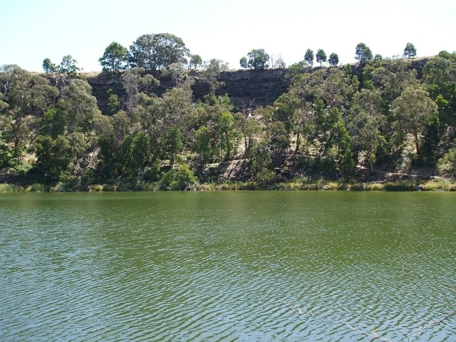
Budj Bim Cultural Landscape (cultural, added 2019) ⟁
Victoria [Budj Bim National Park - Wikipedia]
This unique landscape holds special significance for Gunditjmara people in south-eastern Australia. Budj Bim is home to the earliest living example of aquaculture in the world, with a history of eel farming dating back over 6,000 years.
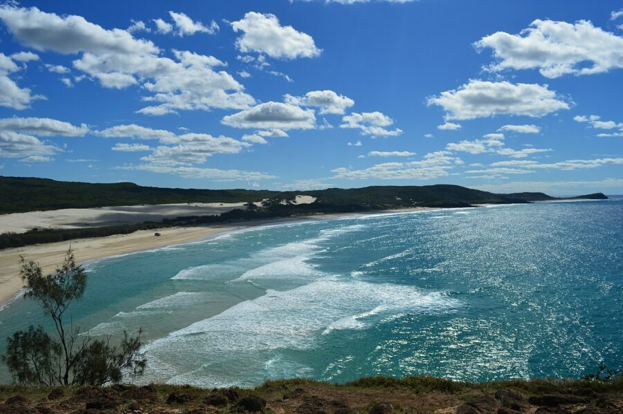
Fraser Island (natural, added 1992) ★
Queensland [Fraser Island - Wikipedia]
Situated just off the east coast, Fraser Island hosts the majestic remnants of tall rainforest sprouting up through the sandy forest bed. Half of the world's perched freshwater dune lakes are also on this island.
Gondwana Rainforests of Australia (natural, added 1986) ⟁
Queensland and New South Wales [Gondwana Rainforests - Wikipedia]
These east coast rainforests are home to a high number of rare and threatened plant species. The geological features of the area also present significant scientific and conservational interest.
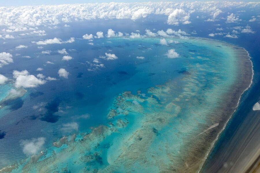
Great Barrier Reef (natural, added 1981) ★
Queensland [Great Barrier Reef - Wikipedia]
Perhaps one of Australia's most iconic natural wonder Great Barrier Reef alongside Uluru, the Great Barrier Reef stretches for over 1,400mi along the north-eastern coast.
The reef is among the world's largest, with 400 species of coral and 1,500 species of fish.
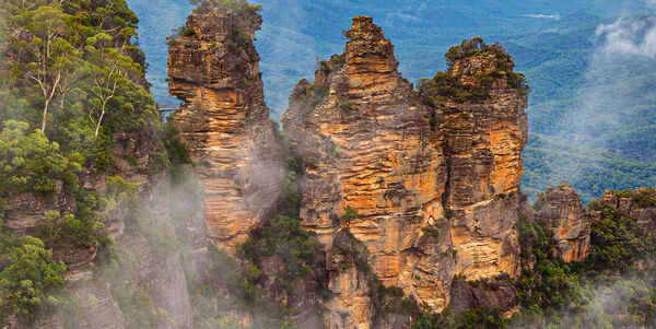
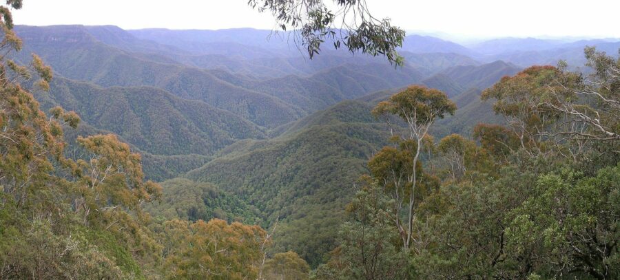
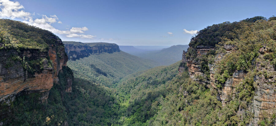
Greater Blue Mountains Area (natural, added 2001)
New South Wales [Greater Blue Mountains Area - Wikipedia]
Situated in New South Wales, the Blue Mountains get their name from the blue mist that forms when the oils of eucalyptus plants evaporates and disperses in the air. Visible blue light in the light spectrum propagates more than other colours causing a blue hue to appear in the air.
The sandstone plateau is mostly forested with sheer cliffs, deep valleys, rivers and lakes and its size is equivalent to twice the landmass of Brunei.
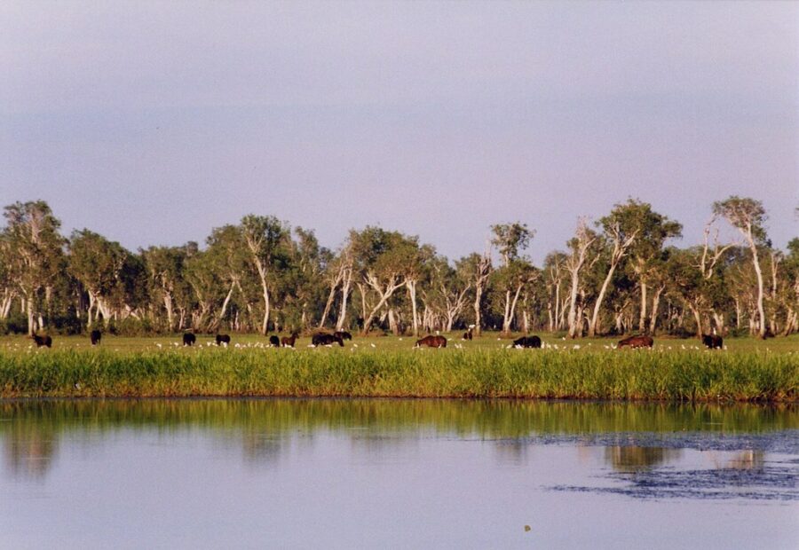
Kakadu National Park (natural, added 1981) ★
Northern Territory [Kakadu National Park - Wikipedia]
Sitting southeast of Darwin, the area is about half the size of Switzerland. Sat in the centre is one of the most productive uranium mines in the world, the Ranger Uranium Mine.
Aboriginal people have occupied the Kakadu area continuously and ancient rock art has been discovered dating back at least 40,000 years. The park is home to four major river systems, six major landforms, over 280 species of birds, 60 mammal species, 50 freshwater species, 10,000 insect species and 1,600 plant species.
Ningaloo Reef (natural, added 2011)
Western Australia [Ningaloo Reef - Wikipedia]
Stretching 160mi along the coast of Western Australia, Ningaloo Reef is Australia's largest fringing coral reef. The word Ningaloo is Australian Aboriginal Wajarri language meaning "high land jutting into the sea". The area is known for its resident whale sharks but is also home to a vast variety of coral and other marine life. During the winter it is part of a migratory route for dolphins, manta rays and humpback whales.

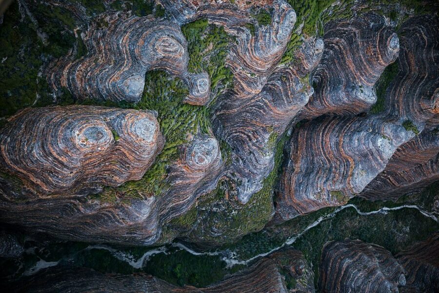
Purnululu National Park (natural, added 2003)
Western Australia [Purnululu National Park - Wikipedia]
Like many traditional aboriginal sites that were claimed by early settlers, the name is a mispronounced interpretation of its local language name that has stuck. Purnululu comes from the word Bullmanlulu which describes the area around the Bungle Bungle range. Bungle Bungle translates to "sand falling away".
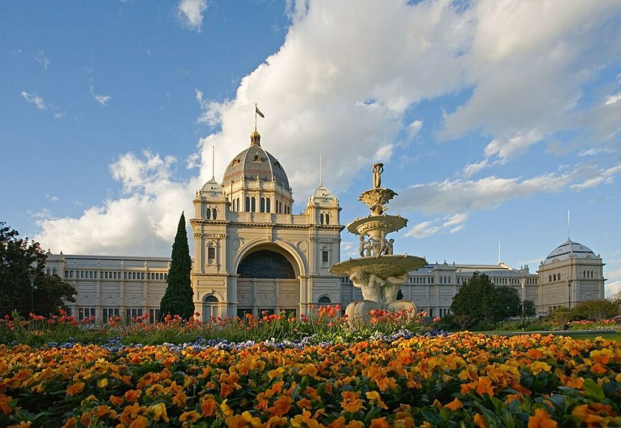
Royal Exhibition Building and Carlton Gardens (cultural, added 2004)
Victoria [Royal Exhibition Building and Carlton Gardens - Wikipedia]
Now to Melbourne where the Royal Exhibition Building sites proudly within Carlton Gardens, a grand Victorian garden laid out over 64 acres and containing many of the cities much-loved attractions.
The gardens were laid out in 1839 when the city was still very much in its infancy. It wasn't until 1880 that the Royal Exhibition Building was constructed to host the Melbourne International Exhibition; the eighth World Fair and the first to be hosted in the Southern Hemisphere. Today it can be visited as part of exhibitions and other events organised by the Melbourne Museum.
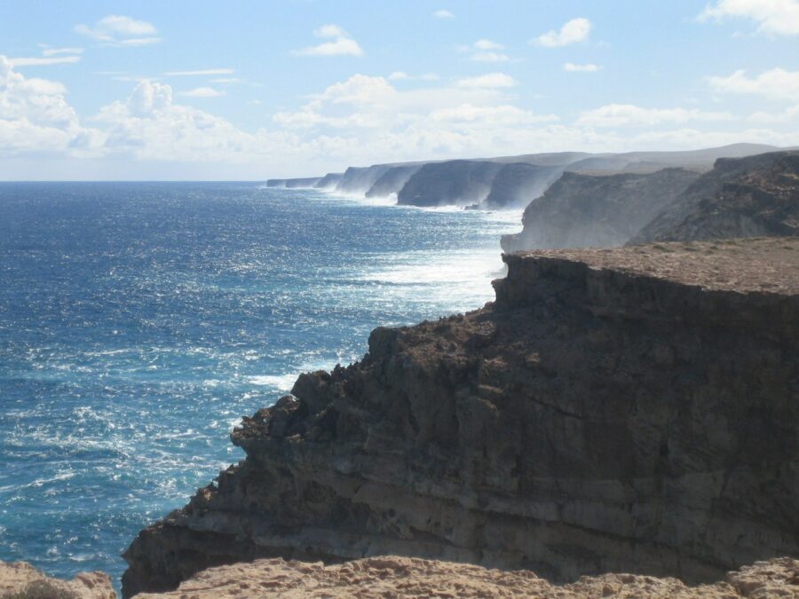
Shark Bay (natural, added 1991)
Western Australia [Shark Bay - Wikipedia]
Shark Bay sits in the westernmost point of the Australian continent, some 700km north of the city of Perth. Amongst its diverse flora and fauna, some of the earliest signs of life are to be found in the form of stromatolites. These fossilised natural forms are made up of blue-green algae and are thought to be about 3.5 billion years old.
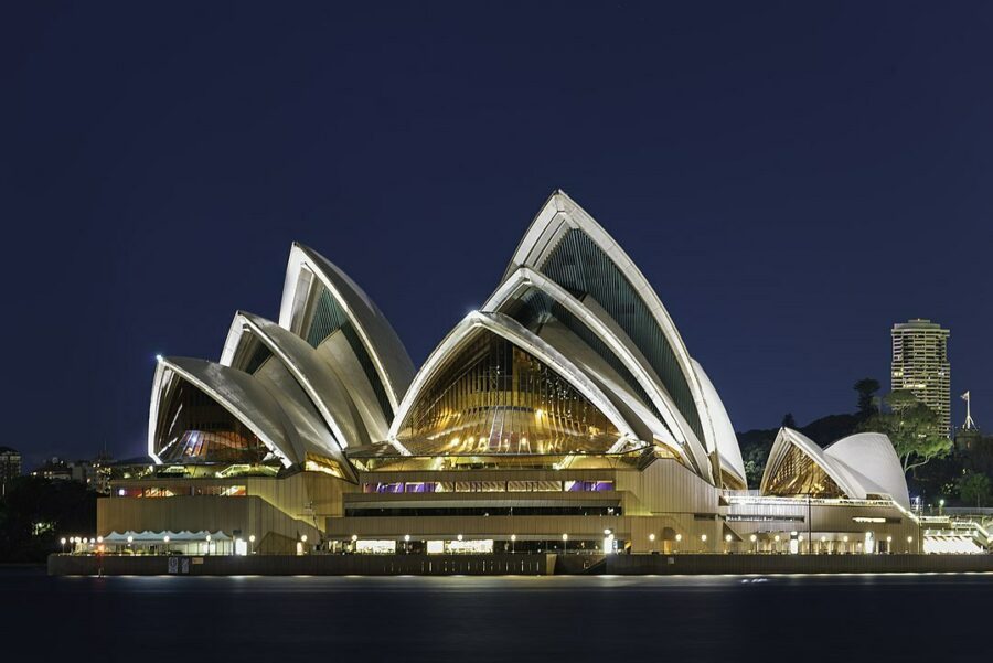
Sydney Opera House (cultural, added 2007) ⟁
New South Wales [Sydney Opera House - Wikipedia]
Name the world's most iconic landmark... It surely has to be Sydney's striking opera house. It is one of the most famous and distinctive buildings of the 20th century and is internationally recognised.
Planning for the redevelopment of the site, then the Fort Macquarie Tram Depot, began in the 1940's and an international design competition was launched in 1955, receiving 233 entries from 32 countries. The winning architect was Jørn Utzon, a Danish designer. Construction began in 1959 and was expected to take just four years. It took 14 years and ran massively over budget. It was opened by Queen Elizabeth ll in 1973.
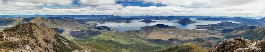
Tasmanian Wilderness (mixed, added 1982)
Tasmania [Tasmanian Wilderness - Wikipedia]
The Tasmanian Wilderness World Heritage Area is one of the largest conservation areas in Australia and one of the last expanses of temperate wilderness in the world. The area is made up of ten national parks.
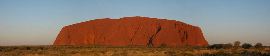
Uluṟu-Kata Tjuṯa National Park (mixed, added 1987) ⟁★
Northern Territory [Uluru-Kata Tjuta National Park - Wikipedia]
This site is home to Uluru (Ayres Rock), perhaps the world's most recognisable rock, and Kata Tjuta (also known as the Olgas). Uluru, situated in Australia's red centre, is a deeply sacred site for the local Aboriginal Pitjantjatjara people who favour its indigenous name Uluru over Ayres Rock.
The site has been a tourist attraction since the 1930s and, until 2019, visitors were able to climb the rock. This activity has since been banned in line with the wishes of the Pitjantjatjara people and to preserve the formation.
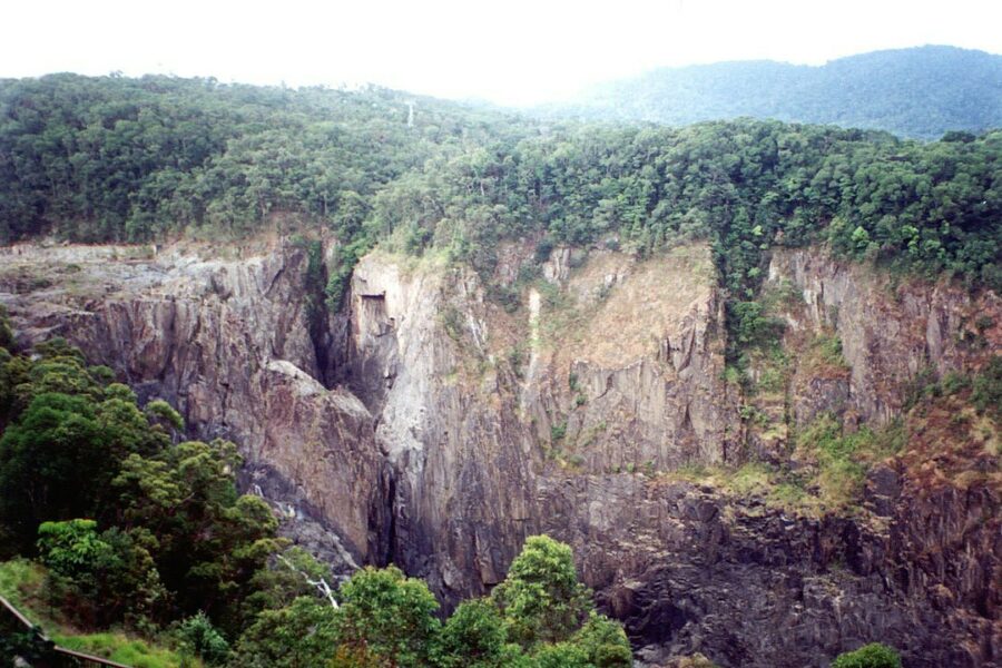
Wet Tropics of Queensland (natural, added 1988) ⟁
Queensland [Wet Tropics of Queensland - Wikipedia]
Sprawling across the north-east Queensland portion of the Great Dividing Range, the Wet Tropics have the highest concentration of primitive flowering plant families in the world. The site is recognised for its many unique plant and animal species. The rainforest is thought to have existed for at least 5,000 years.
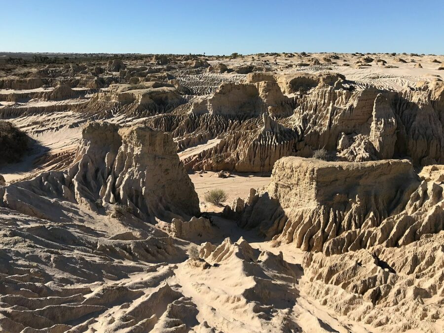
Willandra Lakes Region (mixed, added 1981) ⟁
New South Wales [Willandra Lakes Region - Wikipedia]
The Willandra Lakes are a series of dry lakes, in the semi-arid, far west of the NSW state. The site is naturally and culturally important as it holds clues to earlier human civilisations and the earliest human cremation site has been found within the region.
The Lakes are the traditional meeting place of the Muthi Muthi, Nyiampaar and Barkinji Aboriginal tribes and, whilst the rock formations of the region date back over two million years, Aboriginal people are thought to have inhibited the area for at least 40,000 years, making it one of the oldest human occupation sites in Australia.
Canada
Canada is a treasure house of natural beauty and cosmopolitan sophistication. This nation of vast proportions exudes the irresistible allure of a magnificent land with a deep cultural history and unsurpassed, primordial splendour. Dynamic urban centres contrast pristine landscapes and are home to diverse cultures of aboriginal, European and Asian decent, creating a welcoming nation of truly global citizens.
There are 20 UNESCO World Heritage Sites in mainland Canada. Sites on outlying or overseas territories have not been included.
⟁ National Historic List: National Historic Sites
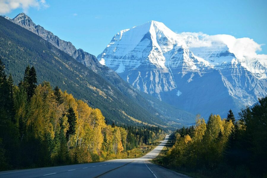
Canadian Rocky Mountain Parks (natural, added 1984)
Alberta and British Columbia [Canadian Rocky Mountain Parks - Wikipedia]
Comprising both the Alberta Rockies and the British Columbia Rockies, this range makes up the Canadian part of the larger North America Rocky massif. The park is made up of four national parks; Banff, Jasper, Kootenay and Yoho and three British Columbia provincial parks; Hamber, Mount Assiniboine and Mount Robson, the latter of which contains the high peak in the complex, at 3,954m (12,972ft).
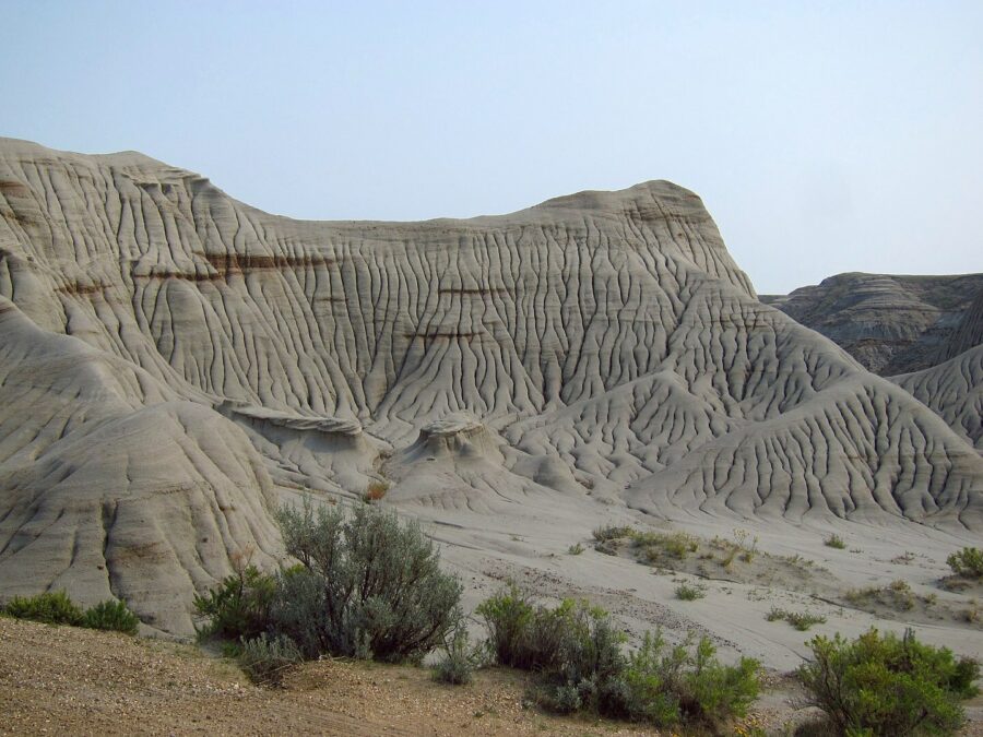
Dinosaur Provincial Park (natural, added 1979) ⟁
Alberta [Dinosaur Provincial Park - Wikipedia]
A two hour drive from Calgary, Dinosaur Provincial Park lies in Red Deer Valley, a landscape noted for its striking terrain and abundance of dinosaur fossils. It is one of the richest fossil sites in the world with 58 dinosaur species and over 500 specimens excavated within the park.
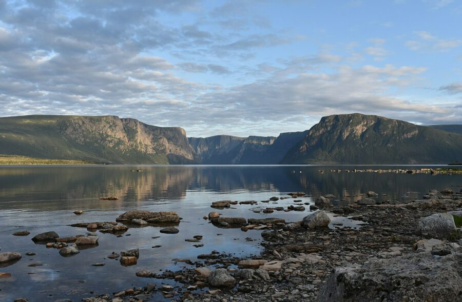
Gros Morne National Park (natural, added 1987)
Newfoundland and Labrador [Gros Morne National Park - Wikipedia]
Gros Morne, located on the west coast of Newfoundland, was added to the World Heritage register in 1987 as it "provides a rare example of the process of continental drift, where deep ocean crust and the rocks of the earth's mantle lie exposed." The park is, most notably, home to moose as well as red and arctic foxes, black bears, lynxes, otters and beavers, and hosts a number of art festivals throughout the year.
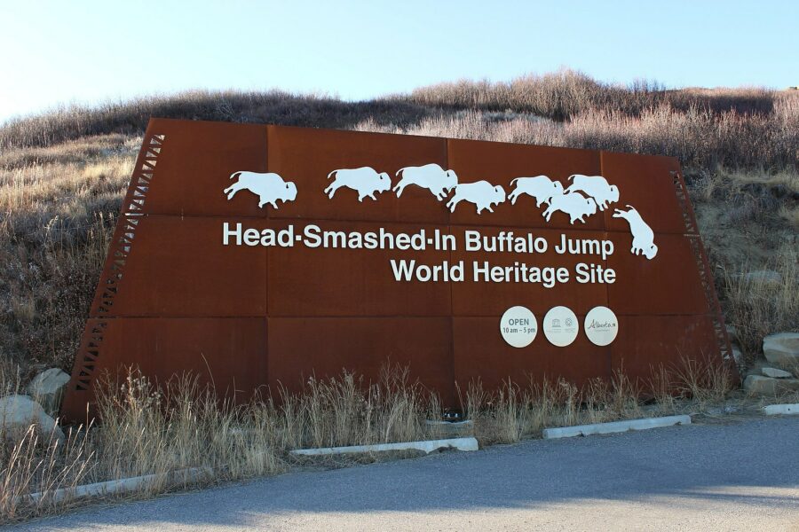
Head-Smashed-In Buffalo Jump (cultural, added 1981) ⟁
Alberta [Head-Smashed-In Buffalo Jump - Wikipedia]
For those unfamiliar with the term, a buffalo jump is an overhanging cliff formation that Native Americans historically utilised to hunt and kill game.
Head-Smashed-In Buffalo Jump, located in Alberta, was once inhabited by the Blackfoot Tribe, one of the first indigenous tribes in Canada. The Museum of Blackfoot Culture is located in the park and exhibits cultural and historic artefacts.
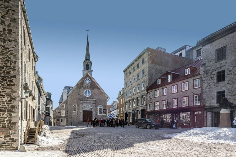
Historic District of Old Québec (cultural, added 1985)
Quebec City, Quebec [Historic District of Old Québec - Wikipedia]
Comprising Haute-Ville (Upper town) and Basse-Ville (Lower town), Quartier latin (or the Latin Quarter) is the historic part of the larger city of Quebec.
Laid out as a military fort by French colonist Samuel de Champlain in 1608, the town was crowned by Fort St Louis located high above the rest of the area giving it an excellent strategic position. After the British Conquest of 1758-1760, the fort was mainly used by the British government with French and British merchants and artisans occupying the lower town.
The fort was destroyed by a fire in 1834. The grand Château Frontenac now stands on the site previously occupied by the fort.
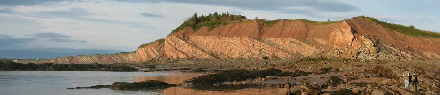
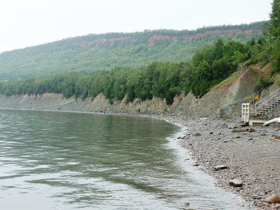
Joggins Fossil Cliffs (natural, added 2008)
Nova Scotia [Joggins Fossil Cliffs - Wikipedia]
A 15km stretch of coastline in the small rural community of Joggins, located in western Nova Scotia, is of huge geological and scientific importance. The fossil cliffs along this part of the coast is the town's claim to international fame.
The fossilised specimens date back approximately 310 million years and Joggins is even mentioned in Charles Darwin's On the Origin of Species.
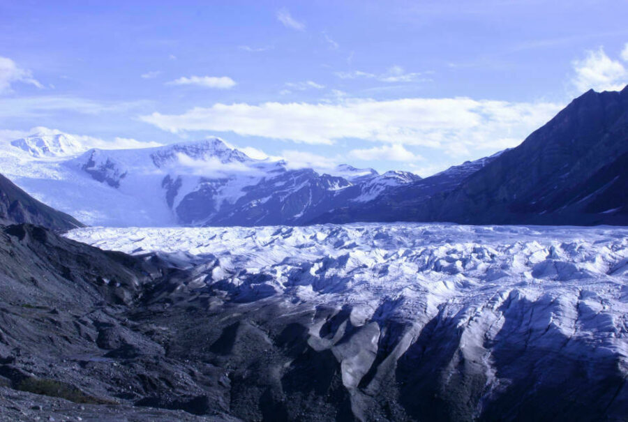
Kluane / Wrangell-St Elias / Glacier Bay / Tatshenshini-Alsek (natural, added 1979) ★
British Columbia (and Yukon, Alaska, United States) [Kluane/Wrangell-St Elias/Glacier Bay/Tatshenshini-Alsek - Wikipedia]
This site is made up of four parks set across two countries; Kluane National Park and Reserve and Tatshenshini-Alsek Provincial Park in Canada, and Wrangell–St. Elias National Park and Preserve and Glacier Bay National Park and Preserve in the US. Together they total an area of 98,391 square kilometres (37,989 square miles). Their international importance is down to the spectacular glacier and icefield landscapes and the wildlife that lives within it.
Landscape of Grand-Pré (cultural, added 2012) ⟁
Nova Scotia [Landscape of Grand-Pré - Wikipedia]
Grand-Pré is a rural community in southern Nova Scotia, it's name translating to Great Meadow in French. The surrounding landscape consisting of marshland, farmland and archaeological sites constitutes "cultural landscape bearing testimony to the development of agricultural farmland using dykes and the aboiteau wooden sluice system, started by the Acadians in the 17th century and further developed and maintained by the Planters and present-day inhabitants".

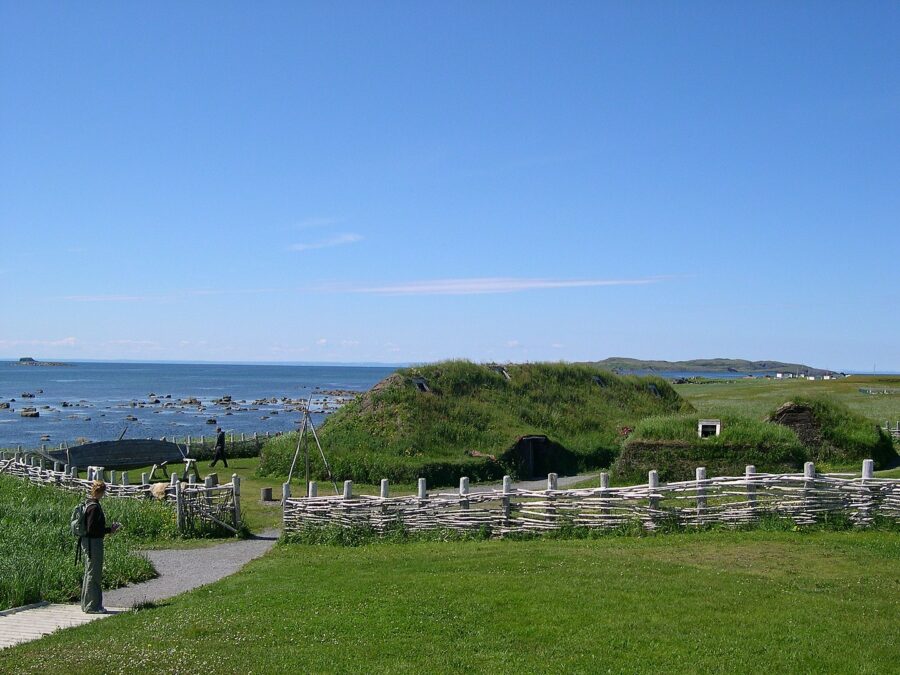
L'Anse aux Meadows National Historic Site (cultural, added 1978) ⟁
Newfoundland and Labrador [L'Anse aux Meadows National Historic Site - Wikipedia]
In the 1960's archaeological work on this site turned out some incredible finds, suggesting evidence of a Norse presence approximately 1,000 years ago. This was big news, and still remains big news as it's the only confirmed Norse site in North America. Historians believe that the site was temporary as no findings of burials, tools, agriculture or animal pens have been discovered.
Miguasha National Park (natural, added 1999)
Gaspé Peninsula, Quebec [Miguasha National Park - Wikipedia]
Known also as Miguasha Fossil Site, the park hosts an abundance of fossils from a crucial time in the evolution of life on earth. The site was discovered in 1842 by Abraham Gesner, a geologist and doctor and pioneer in the petroleum industry. Some of the fossils are on display in the British Museum, London and Royal Scottish Museum, Edinburgh.
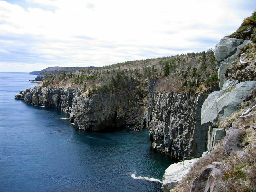
Mistaken Point (natural, added 2016)
Newfoundland and Labrador [Mistaken Point - Wikipedia]
Sitting at the southeastern tip of the Avalon Peninsula in Newfoundland and Labrador, this fossil site contains some of the most diverse and best preserved early period fossils in the world. Later discoveries found some of the oldest fossilised remains of multicellular organisms.
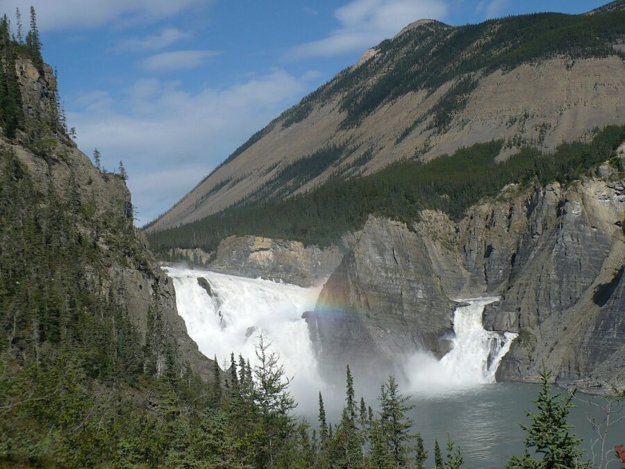
Nahanni National Park (natural, added 1978)
Northwest Territories [Nahanni National Park - Wikipedia]
Nahanni was one of the first four natural heritage sites to be inscribed as a World Heritage Site by UNESCO in 1978. The reserve falls within the Mackenzie Mountains Natural Region, centring around the South Nahanni River which flows through vast canyons and deep valleys. The park also contains some of Canada's largest tufa mounds, the biggest being the North Mound which is 27m high and 74m wide. Its source is deep underground, within the Earth's crust which heats the water to an ambient temperature.
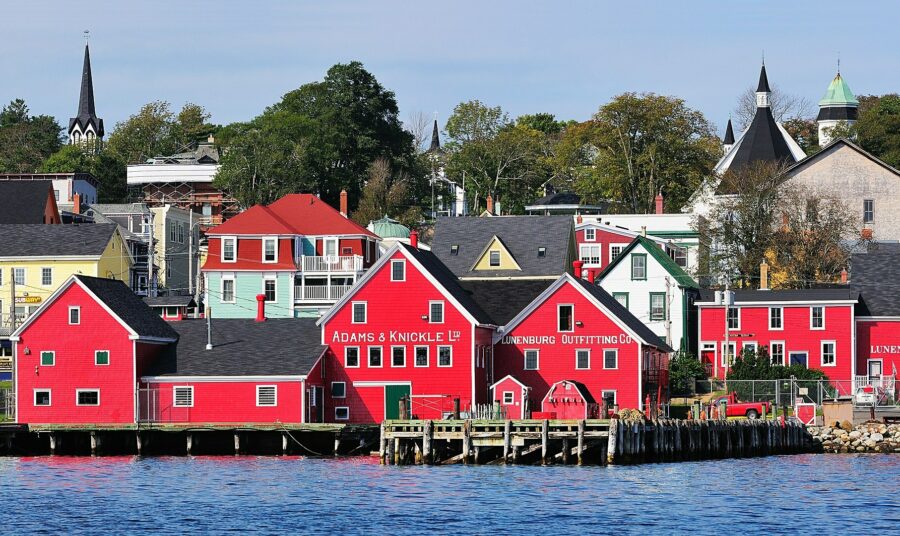
Old Town Lunenburg (cultural, added 1995) ⟁
Nova Scotia [Old Town Lunenburg - Wikipedia]
This port town, sitting on the South Shore of Nova Scotia hides over 250 years of history. Founded in 1753, it was one of the first British attempts at settling Protestants in Nova Scotia. Ultimately it failed but the historic town remains and is one of only two urban settlements to be listed as World Heritage Sites.
Pimachiowin Aki (mixed, added 2018)
Manitoba and Ontario [Pimachiowin Aki - Wikipedia]
Covering more than 11,000 sq miles and including the ancestral lands of four First Nations, Pimachiowin Aki is a newcomer to the UNESCO list, having only been inscribed in 2018. It was added to help protect and preserve the unique area and bring local economic development and employment opportunities.
Red Bay Basque Whaling Station (cultural, added 2013) ⟁
Red Bay, Newfoundland and Labrador [Red Bay Basque Whaling Station - Wikipedia]
Red Bay is a traditional fishing village in Labrador which has been put on the world stage for its notable underwater archaeological sites. The village, historically, was a major Basque whaling station between 16th and 17th centuries. The Basques, mainly from the northern regions of Spain and southwestern corner of France, were among the first people to hunt and catch whales commercially. Several whaling ships have sunk off the coast of the settlement, the discovery of these shipwrecks led to the UNESCO designation.
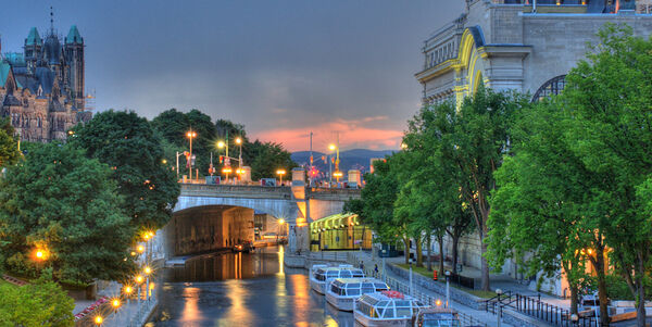
Rideau Canal (cultural, added 2007) ⟁
Ontario [Rideau Canal - Wikipedia]
Opened in 1832 as a result of rising tensions and fear of war with the US, the canal provided a faster and more direct route from Canada's capital city of Ottawa to Lake Ontario and Saint Laurence River at Kingston. But, as railway traffic rose and the motorcar was introduced, ridership fell. Today it is predominantly used for pleasure boating.
To compensate for the gradual uphill rise, a series of 47 locks operate along its route.

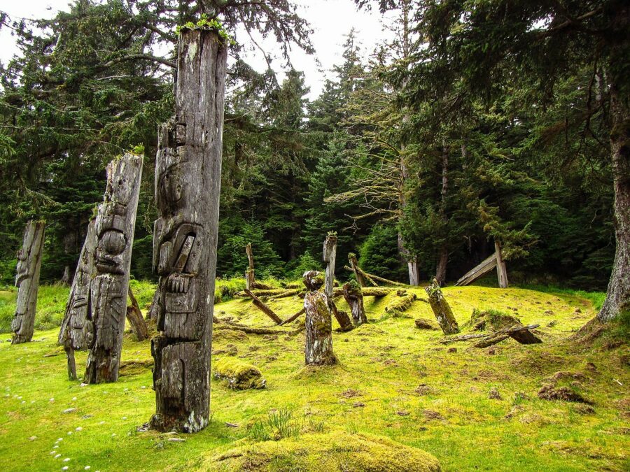
SG̱ang Gwaay Llanagaay (cultural, added 1981) ⟁
British Columbia [SGang Gwaay Llanagaay - Wikipedia]
We'll be honest, we don't know how to pronounce it either! It's more commonly known by its English name of Ninstints. The area was once inhabited by the Haida indigenous people, who erected totem poles, many of which still stand in their original positions and are considered great works of art.
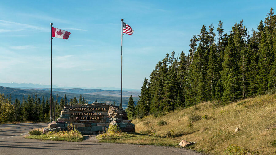
Waterton-Glacier International Peace Park (natural, added 1995) ★
Alberta (and Montana, United States) [Waterton Glacier International Peace Park - Wikipedia]
Consisting of two national parks, one in Canada and one in the USA, united cross-border to form the Waterton-Glacier International Peace Park. The idea of a borderless national park was first put forward by Canadian forest ranger John George Brown and American ranger Albert Henry Reynolds in the late 1800s. It took until 1932 for America and Canada to agree to the formation of a cross-border national park and pass all necessary laws to protect its status.
Wood Buffalo National Park (natural, added 1983) ★
Alberta and Northwest Territories [Wood Buffalo National Park - Wikipedia]
This national park is the second largest in the world, after the Northeast Greenland National Park. To put it into perspective, its larger than the land area of Switzerland!
Established in 1922, its founding mission was to protect the world's largest herd of free-roaming wood bison with a population today of over 5,000.
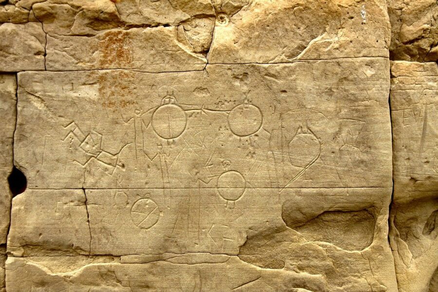
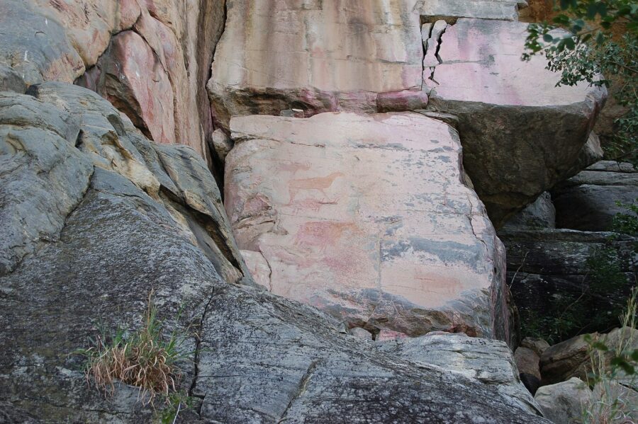
Writing-on-Stone / Áísínai'pi (cultural, added 2019) ⟁
Alberta [Writing-on-Stone/Áisíani'pi - Wikipedia]
Known also as Writing-on-Stone Provincial Park, this region serves as both a nature reserve and a protected historical site. The First Nation stone carvings and paintings below show warriors carrying body shields, prior to the arrival of horses on the continent.
New Zealand
New Zealand is a country with a landmass bigger than the UK but with just one fourteenth the size of its population so a quiet spot isn't hard to come by.
It's a country which embraces its unique and rich culture, appreciates good food, wine and beer and, most importantly, is friendly and welcoming.
There are just two UNESCO World Heritage Sites in New Zealand. One on the North Island, and one on the South.
⟁ National Historic List: National Historic Landmarks
Te Wahipounamu (natural, added 1990)
South Island [Te Wahipounamu - Wikipedia]
Covering 26,000 sq kilometres and incorporating four national parks, Te Wahipounamu climbs along the South Island's southwestern coast. The four national parks are Aoraki / Mount Cook, Fiordland, Mt Aspiring and Westland. Collectively, they are thought to contain some of the best modern representations of the original flora and fauna of the Gondwana supercontinent that existed around 550 million years ago and grouped together New Zealand with Australia, South America, Africa, Antarctica, Arabia and the Indian Subcontinent.
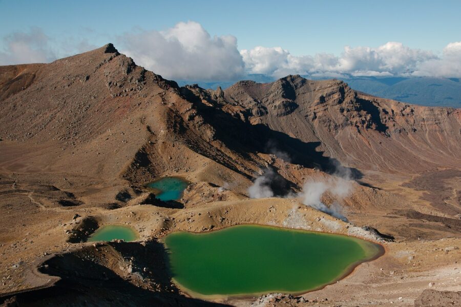
Tongariro National Park (mixed, added 1993)
North Island [Tongariro National Park - Wikipedia]
Established in 1887, Tongariro was the sixth national park in the world to be created and is the oldest in New Zealand. The park contains several active volcanoes, religious Mauri sites, summits and many towns. It is also home to what is often thought of as the world's best one-day hike; the famed Tongariro Alpine Crossing.
USA
What is America? America is bright lights and big cities. It's jazz, soul and blues. It's BIG food. It's culture, from art to architecture, music to museums. America has a bit of everything, for everyone. There are 4 million miles of highways that criss-cross the country, if stretched out they would reach the moon and back 16 times!
There are 21 UNESCO World Heritage Sites in mainland America. Sites on outlying or overseas territories have not been included.
⟁ National Historic List: US National Register of Historic Places
Other historic registers include state-wide, city-wide and local lists.
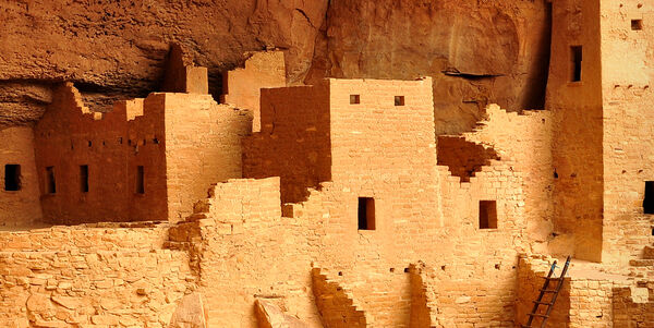
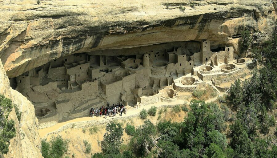
Mesa Verde National Park (natural, added 1978) ⟁
Colorado [Mesa Verde National Park - Wikipedia]
Home to America's best-preserved Puebloan archeological sites, Mesa Verde occupies 52,485 acres across the Four Corners region of the southwest (Utah, Colorado, Arizona and New Mexico). Cliff Palace is the best known of the Puebloan settlements and it is the largest such settlement in the country.
The name 'Mesa Verde' is Spanish, although it is a misnomer as true mesa formations are almost perfectly flat. If named as per its proper geological name, it would be Cuesta Verde.
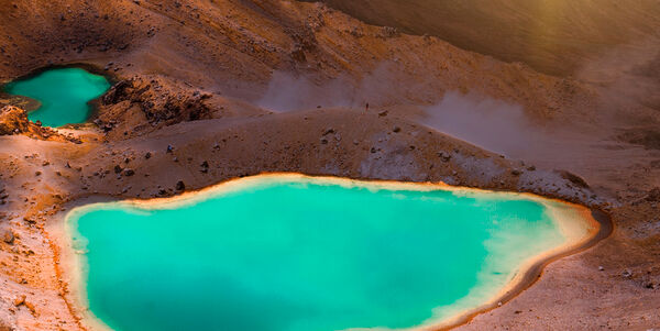
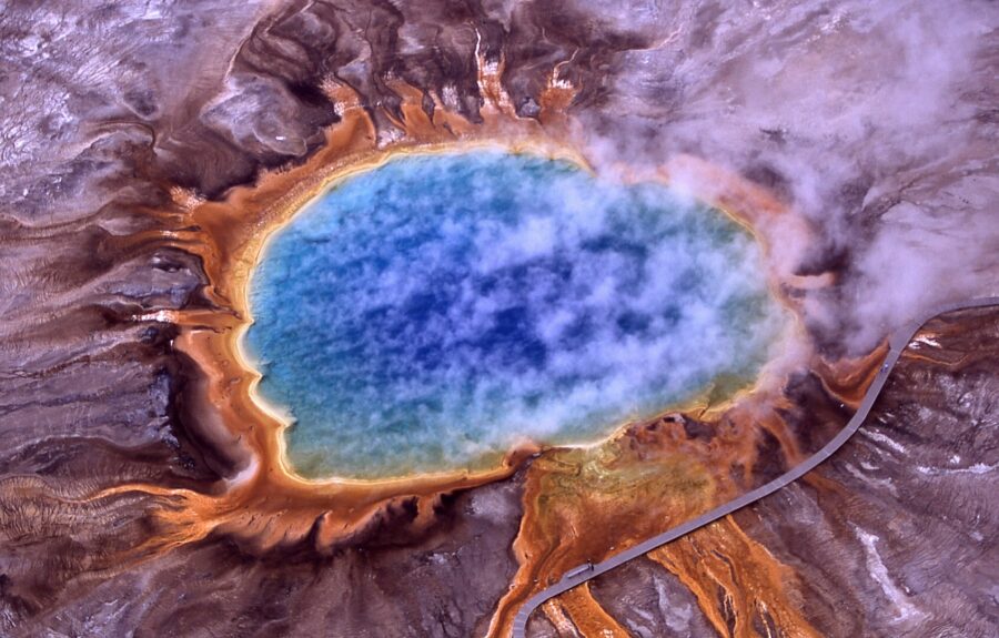
Yellowstone National Park (natural, added 1978) ★
Wyoming, Montana, Idaho [Yellowstone National Park - Wikipedia]
Located mostly in the northwestern corner of Wyoming and spilling over into neighbouring Montana and Idaho, Yellowstone, under President Ulysses S. Grant in 1872, was the first national park to be established in the US and, by some accounts, in the world.
Geologically it is home to waterfalls, geothermal pools and geysers, lakes, canyons, rivers and the Yellowstone Caldera which, although dormant, is the largest supervolcano on the continent.
Kluane / Wrangell–St. Elias / Glacier Bay / Tatshenshini-Alsek (natural, added 1979) ★
Yukon, Alaska (and British Columbia, Canada) [Kluane /Wrangell-St. Elias / Glacier Bay / Tatshenshini-Alsek - Wikipedia]
This site is made up of four parks set across two countries; Kluane National Park and Reserve and Tatshenshini-Alsek Provincial Park in Canada, and Wrangell–St. Elias National Park and Preserve and Glacier Bay National Park and Preserve in the US. Together they total an area of 98,391 square kilometres (37,989 square miles). Their international importance is down to the spectacular glacier and icefield landscapes and the wildlife that lives within it.
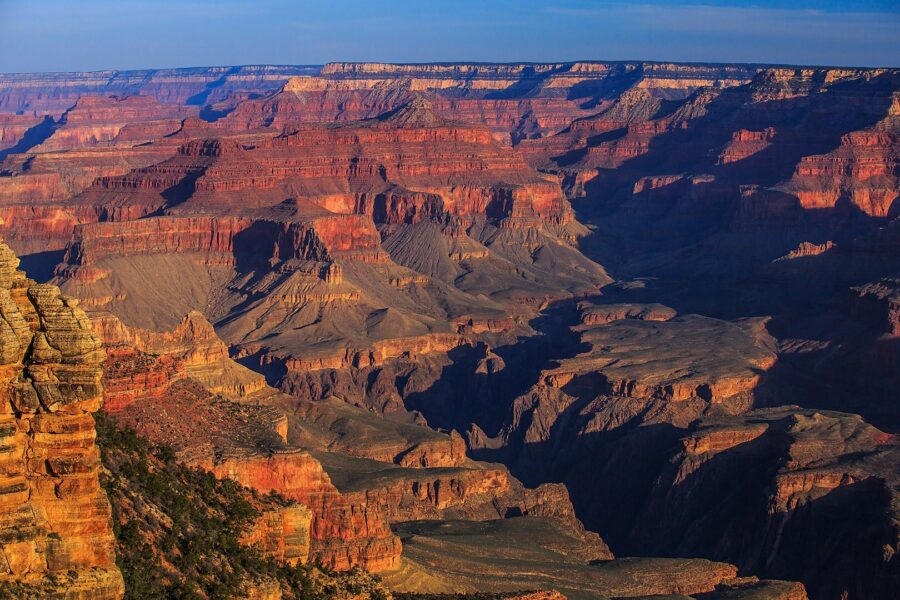
Grand Canyon National Park (natural, added 1979)
Arizona [Grand Canyon National Park - Wikipedia]
The rusty orange rocks of the Grand Canyon are recognised across the world as a symbol of America. Amongst the mesas and plateaus, deep in the vast valleys of the park flows the mighty Colorado River, considered by some accounts as a Wonder of the World.
Mer six million tourists visited the park in 2017, making it the second most-visited national park in the US, after the Great Smoky Mountains National Park.
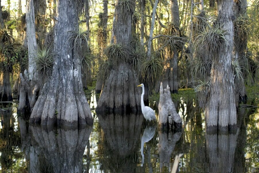
Everglades National Park (natural, added 1979) ★
Florida [Everglades National Park - Wikipedia]
Comprising of a unique natural region of tropical wetlands, the ecosystem at Everglades isn't found anywhere else on earth, hence its designation as a UNESCO World Heritage Site. The park was created to protect the fragile ecosystem in which it hosts, unlike other national parks which are mostly established to protect geological features.
Over 700 marine, bird, mammal and reptile species have made the park their home. Of those 700 species, 36 are endangered or protected including the Florida Panther, American Crocodile and West Indian Manatee.
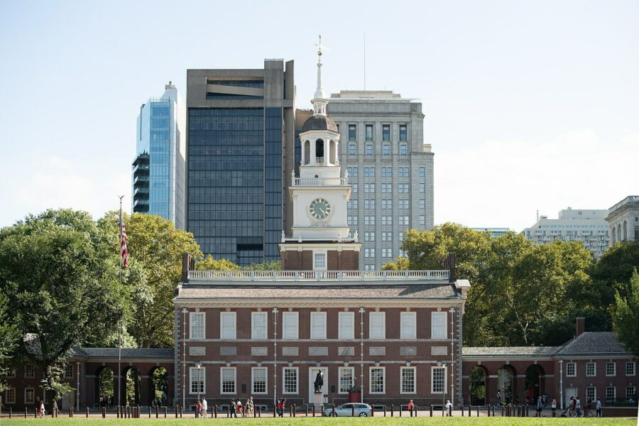
Independence Hall (cultural, added 1979) ⟁
Pennsylvania [Independence Hall - Wikipedia]
Independence Hall's importance is both historic and political. Completed in 1753, it served as the Pennsylvania State Capitol until its relocation in 1799 and hosted the 1915 convention, overseen by former president William Howard Taft, which saw the creation of the League to Enforce Peace, later to become the United Nations.
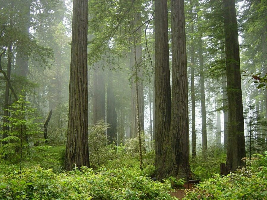
Redwood National and State Parks (natural, added 1980) ★
California [Redwood National and State Parks - Wikipedia]
Redwood is a superpark, comprising of three state parks and the Redwood National Park with a total land area of 139,000 acres along the coast of northern California.
Coast Redwood trees are among the tallest and oldest tree species on earth, reaching heights of over 100m. At 115m tall, Hyperion is the tallest tree in Redwood and the tallest known living tree in the world.
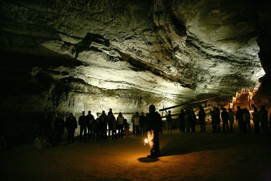
Mammoth Cave National Park (natural, added 1981) ★
Kentucky [Mammoth Cave National Park - Wikipedia]
Setting another impressive world record, Mammoth Cave, situated within Mammoth Cave National Park, is longest known cave system in the world at 412 miles (663km) long.
The National Park Service offers walking tours of the cave network and, most famously, an underground river boat tour.
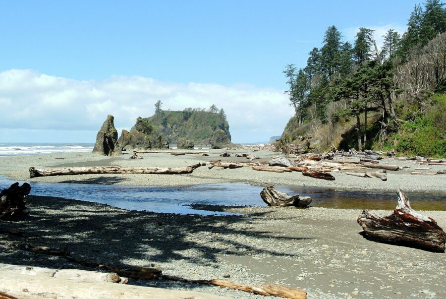
Olympic National Park (natural, added 1981) ★
Washington [Olympic National Park - Wikipedia]
Spread across nearly one million acres, this park hosts three distinct ecosystems; subalpine forest and wildflower meadow, temperate forest and coast, each of these areas are home to different animal and plant species. Several large mammals, around 50 small mammals and 14 marine species are known to live in the park including black bears, bobcats, mountain goats, porcupines, bats, minke whales, orcas and humpback whales.
Cahokia (mixed, added 1982) ⟁
Illinois [Cahokia - Wikipedia]
Although nothing much remains, Cahokia was once a bustling ancient city which, at its peak, was home to up to 18,000 people, larger than the population of London at the time. It is thought to have been founded in the 9th century and existed for around five hundred years before it was eventually abandoned in the 14th century. Now, all that remains are large earth mounds, reconstructed walls give some insight into how the city might once have looked.
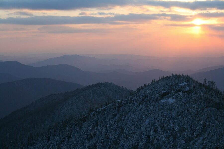
Great Smoky Mountains National Park (natural, added 1983) ★
Tennessee, North Carolina [Great Smoky Mountains National Park - Wikipedia]
Straddling the border between Tennessee and North Carolina, Great Smoky Mountains National Park is America's most-visited national park, with over 12 million visitors in 2019.
Some of the oldest rocks found within the park date back over a billion years, formed during the Precambrian period; the earliest period in earth's history. At least 95% of the park is forested, with over 100 species of trees. In addition, there are 1,400 species of flowering plants and 4,000 species of non-flowering plants!
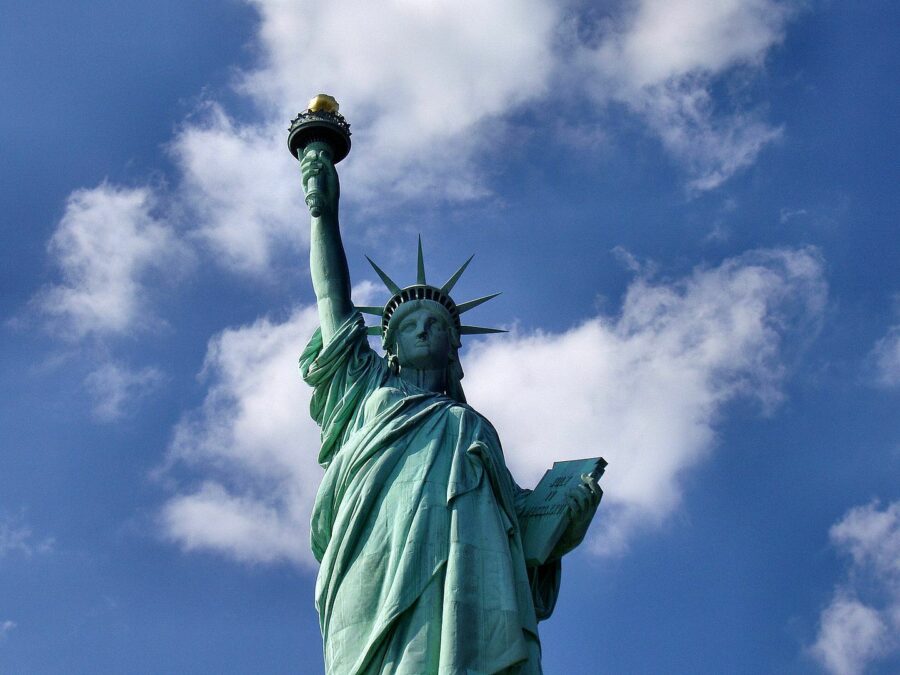
Statue of Liberty (cultural, added 1984) ⟁
New York [Statue of Liberty - Wikipedia]
An international icon of freedom and enduring symbol of the United States of America, the Statue of Liberty was gifted to the US by France. Designed by French sculptor Frédéric Auguste Bartholdi and built to framework specifications by Gustave Eiffel, this giant neoclassical statue stands proudly in New York harbour, greeting immigrants arriving by sea.
Construction began in Paris in 1877 and a year later Liberty's head was complete and put on display at the Paris World's Fair. Work continued for several years in France until each section was complete, it was then packed up, shipped to New York and assembled onsite. A ceremony of dedication was held on the afternoon of October 28, 1886.
The statue is not only listed as a UNESCO World Heritage Site, but also as a US National Monument and New York City Landmark and is registered on the US National Register of Historic Places and the New Jersey Register of Historic Places.
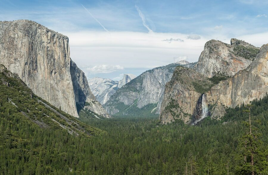
Yosemite National Park (natural, added 1984)
California [Yosemite National Park - Wikipedia]
Think of Yosemite and images of sheer granite cliffs, colossal waterfalls, crystal clear waters, giant sequoia groves and vast glaciers come to mind. It is listed as a UNESCO World Heritage site for good reason; the park is home to 20% of California's plant species, 160 rare plants, rare local geological formations and unique soils.
Its rock formations were formed about 10 million years ago and during the early glacial period, snow and ice accumulated forming glaciers up to 1,200m (4,000ft) thick.
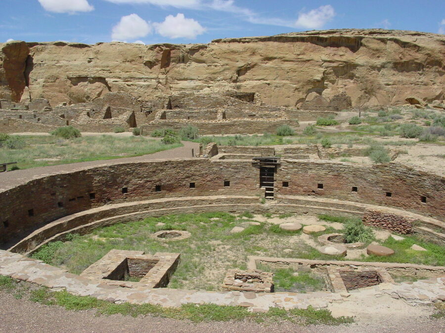
Chaco Culture National Historical Park (cultural, added 1987) ⟁
New Mexico [Chaco Culture National Historic Park - Wikipedia]
Preserving the most important collection of pre-Columbian ruins the United States, Chaco Culture National Historic Park covers over 30,000 acres in the Four Corners region. The sites are considered sacred to the Hopi and Peublo tribes and both tribes work together with the National Parks Service to preserve and protect the remains.
Monticello and the University of Virginia (cultural, added 1987) ⟁
Virginia [Monticello and the University of Virginia - Wikipedia]
Monticello, meaning 'Little Mountain' in Italian, was the home of Thomas Jefferson, third President of the United States, from 1770 until his death in 1826. Jefferson inherited the land from his father aged 26 and began cultivating tobacco, mixed crops and wheat. Construction started on Monticello in 1768, designed entirely by Jefferson and built by free workers and enslaved labourers. The South Pavilion was finished by 1770 and he moved in with his wife that same year. Although structurally complete by 1809, Jefferson continued working on the residence until his death 17 years later.
The University of Virginia, Jefferson's ideal academical village, was also designed by him in neoclassical styles. Both the University building and Monticello are listed as a UNESCO World Heritage Site.

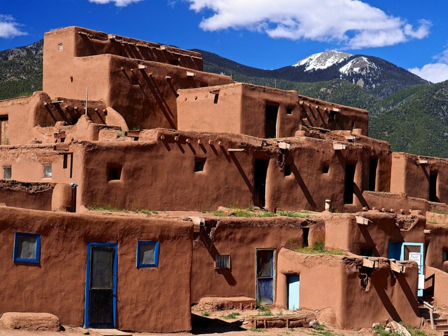
Taos Pueblo (cultural, added 1992) ⟁
New Mexico [Taos Pueblo - Wikipedia]
Historians and researchers are unsure about the early history or culture of this area because natives almost never discuss their beliefs or customs with outsiders and their language has never been deciphered. It is known that these ancient pueblos belong to a Taos-speaking community of modern Puebloan people who still inhabit them.
Each house typically contains two rooms; one for living and sleeping and the other for cooking, eating and storage. They are thought to be the oldest continuously inhabited communities in the country.
The nearby modern city of Taos has been heavily influenced by these rounded, red clay structures.
Carlsbad Caverns National Park (natural, added 1995)
New Mexico [Carlsbad Caverns National Park - Wikipedia]
Although the size of this national park totals 46,000 acres, its main attraction is below its undulating heathlands. The cave network is vast and contains many 'rooms' including one known simply as the 'Big Room'. And big it is, totalling 1,220m (4,000ft) long and 78m (255ft) high.
The caves and national park are protected from development by law, but in the 1950s, prior to any law existing, a cafeteria was build in the caves, known as the 'Underground Lunchroom'.

Waterton-Glacier International Peace Park (natural, added 1995) ★
Montana (and Alberta, Canada) [Waterton-Glacier International Peace Park - Wikipedia]
Consisting of two national parks, one in Canada and one in the USA, united cross-border to form the Waterton-Glacier International Peace Park. The idea of a borderless national park was first put forward by Canadian forest ranger John George Brown and American ranger Albert Henry Reynolds in the late 1800s. It took until 1932 for America and Canada to agree to the formation of a cross-border national park and pass all necessary laws to protect its status.
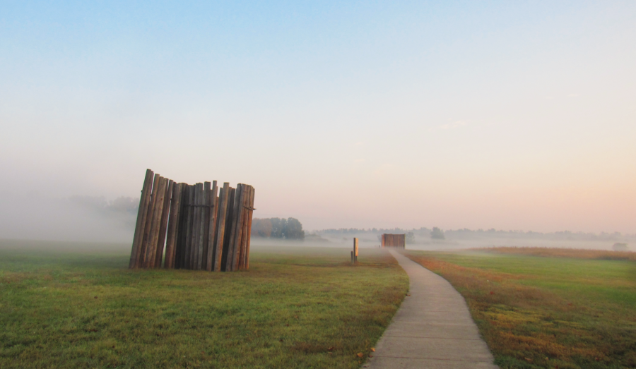
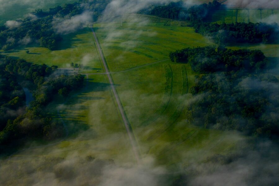
Monumental Earthworks of Poverty Point (cultural, added 2014)
Louisiana [Monumental Earthworks of Poverty Point - Wikipedia]
Approaching the site, it seems rather underwhelming; a series of grassy mounds and some concentric undulating ground. But as one learns more, we find that these earthworks are the archeological remains of a prehistoric indigenous settlement, the concentric mounds forming the main ceremonial centre of the community which was inhabited between 1730 BC and 1350 BC.
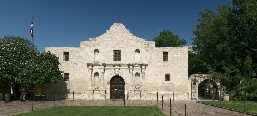
San Antonio Missions (cultural, added 2015) ⟁
Texas [San Antonio Missions - Wikipedia]
The San Antonio Missions consists of not just one mission site, but five and a historic ranch. Established by the Catholic religious orders in the late 17th and early 18th centuries, their aim was to spread christian beliefs among the local natives.
The five missions are: Mission Espada (est. 1690), Mission San Juan Capistrano (est. 1731), Mission San José (est. 1720), Mission Concepción (est. 1711) and Alamo Mission (est. 1718). The ranch was established some time between 1750 and 1760 and served as an administrative centre for the missions, cultivating crops and livestock for the missions' population.
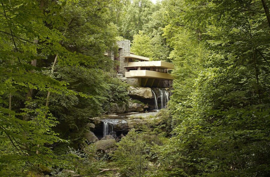
The 20th-Century Architecture of Frank Lloyd Wright (cultural, added 2019) ⟁
Arizona, California, Illinois, New York, Pennsylvania, Wisconsin [The 20th-Century Architecture of Frank Lloyd Wright - Wikipedia]
Frank Lloyd Wright is one of America's most celebrated 20th century architects and is known across the world for his Prairie School style, modern, modular and layered structures.
During his lifetime he designed over 400 buildings and structures, mostly in America but also in Canada and Japan. Perhaps his most recognised works are Falling Water in Pennsylvania - designed in 1939 and built on the Bear Run river, straddling a waterfall. Its owners wanted a large weekend residence, larger than the plot would allow for but Wright solved this by designing a cantilevered structure that extended over the river. Its distinctive vertical and horizontal lines and use of locally quarried stone somehow harmonise with nature, something that Write created effortlessly.
His other notable structure is New York's Solomon R. Guggenheim Museum, often just called The Guggenheim. Wright rewrote the design books by completely changing up how people should move around a museum. A traditional museum operates on the idea that collections are displayed in different rooms and people move through them before having to retrace their steps to exit. Wright created an open atrium and proposed that visitors catch an elevator to the top floor and make their way down the gently sloping ramp that spiralled downward to the last artwork on the ground floor.
The gallery contains artworks by Cézanne, Braque, Léger, Metzinger, Modigliani and many other major impressionist, post-impressionist, early modern and contemporary artists.
Southern Africa
Southern Africa shouldn't be confused with South Africa, we're talking about the entire southern tip of the African continent, taking in Botswana, Lesotho, Namibia, South Africa, Zambia and Zimbabwe.
The varied landscape of this part of the world, from desert to wetlands, forest to mountain ranges has a very rich and long cultural story especially in regards to early human history.
There are 15 UNESCO World Heritage Sites in Southern Africa. Sites on outlying or overseas territories or islands off the mainland have not been included.
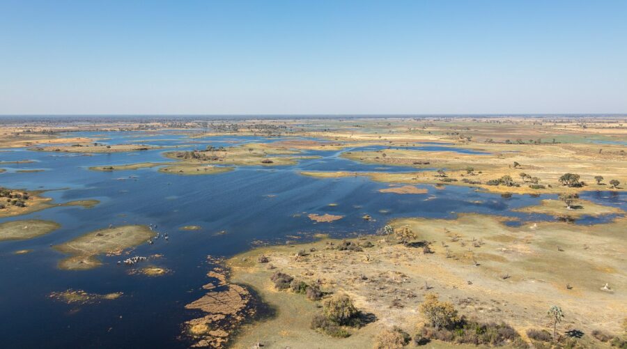
Okavango Delta (natural, added 2014) ★
Botswana [Okavango Delta - Wikipedia]
This is a delta with a difference; it doesn't flow into an ocean. Okavango Delta is an inland delta. The Okavango River flows into the Okavango Grasslands, a vast marshland and seasonal flood plain which, when flooded in peak season, contains up to 2.6 miles³ (11km³) of water spread over up to 5,800 miles² (15,000km²).
The marshlands are home to the big five game animals, those being the lion, leopard, African buffalo, African bush elephant and rhinoceros.
Tsodilo (cultural, added 2001)
Botswana [Tsodilo - Wikipedia]
Its history spans many millennia, it's known to some as the 'Louvre of the Desert' because of its high concentration of early human rock paintings, thought to number over 4,500.
While the rock art dates back about 100,000 years, it is thought that humans have settled in the area for well over a millennia, using the rocks as shelter among the harsh landscape of the Kalahari Desert.
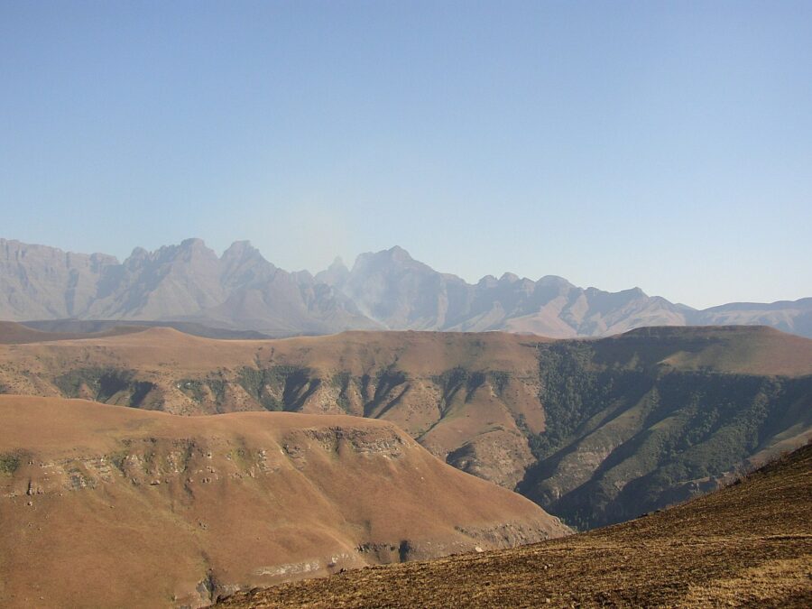
Maloti-Drakensberg Park (mixed, added 2000) ★
Lesotho/South Africa [Maloti-Drakensberg Park - Wikipedia]
Formed in 2001 from the merging of five national parks including Golden Gate Highlands National Park, Qwa Qwa National Park, Sterkfontein Dam Nature Reserve, uKhahlamba-Drakensberg Park, Royal Natal National Park and Sehlabathebe National Park.
The park has exceptional natural beauty and a long cultural history. The San people have inhabited the mountainous areas of the reserve for over four millennia and have left their mark in the form of rock paintings and carvings.
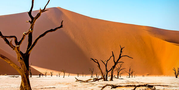
Namib Sand Sea (natural, added 2013) ★
Namibia [Namib Sand Sea - Wikipedia]
Namibia Sand Sea is truly unique in that it is the only coastal desert in the world with large sand dunes. These dunes somewhat influence the weather as they stand between the cooler water-laden air carried towards the land by strong winds and the warm, dry air of the desert, therefore causing dense fog and strong currents. The coastline is sometimes called the 'Skeleton Coast' because of how many shipwrecks can be found peppered along it, some as many as 50m (55 yards) inland due to the gradual reclaiming of land from the sea.

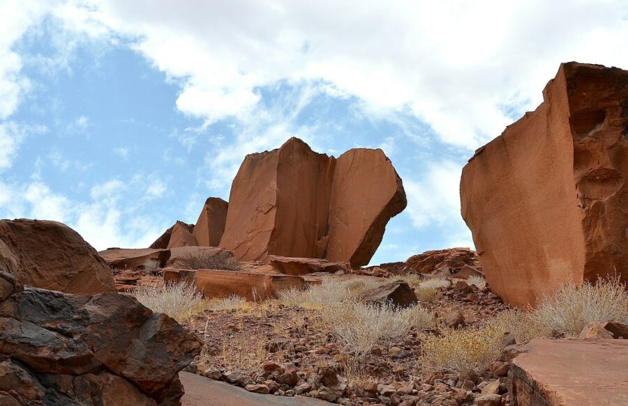
Twyfelfontein or ǀUi-ǁais (cultural, added 2007) ⟁
Namibia [Twyfelfontein - Wikipedia]
Its name translates to 'jumping waterhole', yet this site is so much more. Twyfelfontein is a site of national and international importance as it holds clues to early human settlements through its ancient rock engravings.
The site was Namibia's first UNESCO World Heritage site, designated in 2007 for its cultural importance. It is home to Africa's largest concentration of rock engravings dating from the late Stone Age.
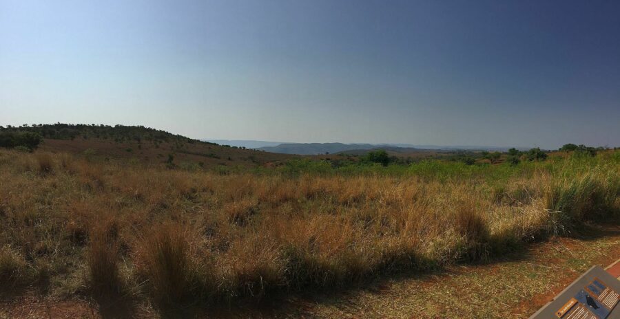
Barberton Makhonjwa Mountains (natural, added 2018)
South Africa [Barberton Makhonjwa Mountains - Wikipedia]
Within this small mountain range lies some of the oldest exposed rock on the planet, dating back 3.6 billion years. Gold deposits can also be found in the reserve and findings of extraterrestrial organic materials have been discovered, suggesting that the area was likely the site of a meteorite impact some 3 billion years ago.

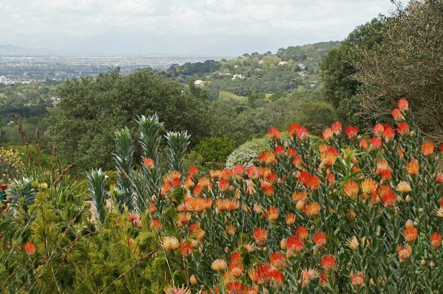
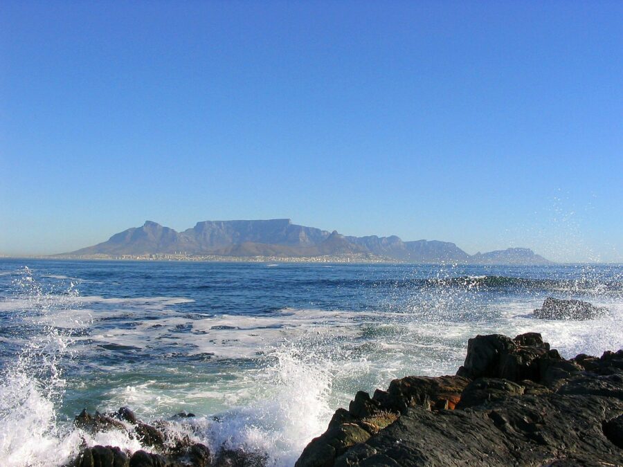
Cape Floral Region Protected Areas (natural, added 2004) ★
South Africa [Cape Floral Region Protected Areas - Wikipedia]
Despite being the smallest of the six recognised floral kingdoms in the world, Cape Floral has extraordinarily high diversity. About 69% of all plants within the protected areas are native species. But, while this area has flourished in previous years, it is now thought to be experiencing one of the most rapid rates of extinction in the world, competing with habitat loss, land degradation and invasive plants.
Fossil Hominid Sites of South Africa (cultural, added 1999)
South Africa [Fossil Hominid Sites of South Africa - Wikipedia]
The self-proclaimed Cradle of Humankind, this 40,000 hectare site contains a complex of limestone caves, home to some of the oldest fossilised remains of early humans. The Sterkfontein Caves have produced more than a third of early hominid fossils ever found prior to 2010. Early humans would've lived across the African continent but their remains can only be found in locations where conditions were right for the preservation of remains into fossils.
iSimangaliso Wetland Park (natural, added 1999) ★
South Africa [iSimangaliso Wetland Park - Wikipedia]
Africa's third largest protected area and one the largest coastal reserves on the continent, iSimangaliso Wetland Park, formally known as the Greater St. Lucia Wetland Park, stretches along 230km (143mi) of coastline.
iSimangaliso means 'miracle' in Zulu, the most widely-spoken home language in South Africa.

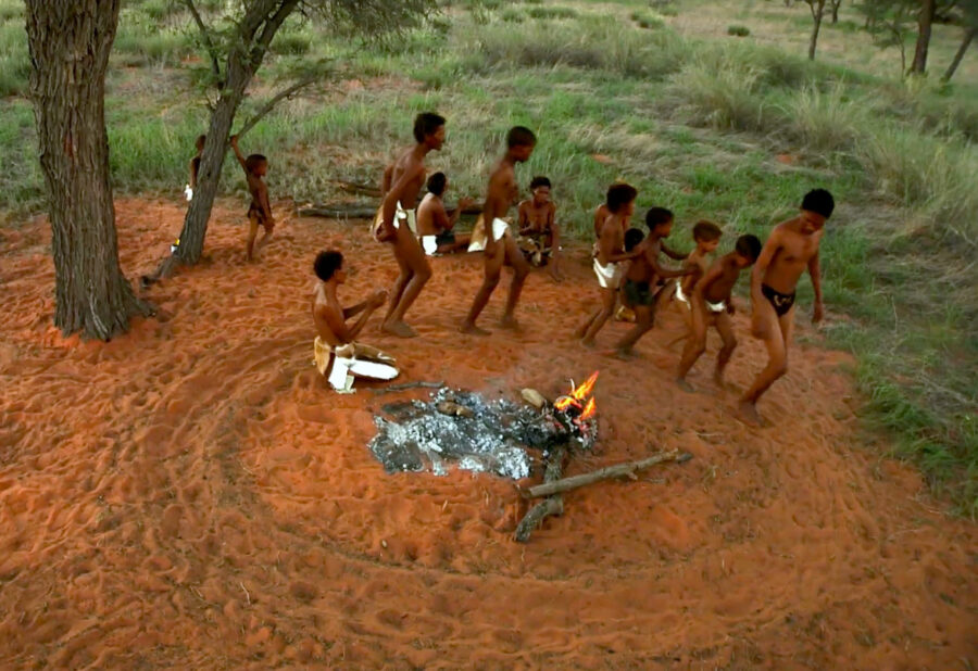
ǂKhomani Cultural Landscape (cultural, 2017)
South Africa [Khomani Cultural Landscape - UNESCO]
Sitting on the border between Botswana and Namibia, this area, like previously mentioned cultural spaces, is the site of Stone Age human remains. UNESCO named this site a World Heritage Site in 2017 due to the cultural practices of the Khomani San people and how they adapted to the harsh desert conditions.
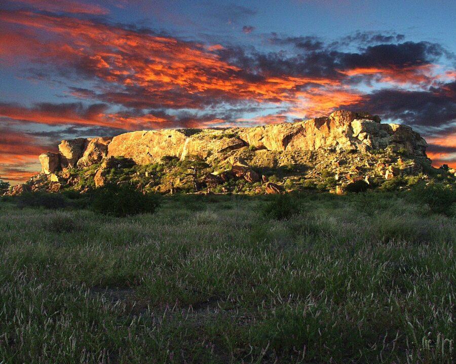
Mapungubwe Cultural Landscape (cultural, added 2003) ★
South Africa [Mapungubwe Cultural Landscape - Wikipedia]
The area now occupied by Mapungubwe National Park was once the Kingdom of Mapungubwe, a state in South Africa. While this ancient state only lasted 80 years, it has had a lasting legacy on the land and many archeological digs have found artefacts that are thought to be the belongings of its inhabitants. Some of these artefacts are on display at the Mapungubwe Museum in Pretoria.
The Mapungubwe community is thought by many leading experts to be the first hiarachial-based social system in southern Africa. Its leaders were separated and high rank than its inhabitants.
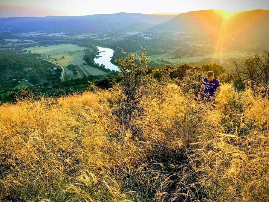
Richtersveld Cultural and Botanical Landscape (cultural, added 2007)
South Africa [Richtersveld Cultural and Botanical Landscape - Wikipedia]
Richtersveld is a desert landscape characterised by rugged gorges, high, craggy mountains and the mighty Orange River which flows through the varied landscape and forms a natural border with Namibia. It is regarded as the only arid biodiversity hotspot on earth, hence its designation as a UNESCO World Heritage Site.
Alongside animal species such as rheboks, zebra, baboons, monkeys, leopards and cobras, live the Nama people who seasonally migrate to the area with their livestock.

Robben Island (cultural, added 1999) ⟁
South Africa [Robben Island - Wikipedia]
Robben Island, just off the coast of Cape town, is perhaps best known for its role in Nelson Mandela's imprisonment. Of the 27 years he was incarcerated, he spend 18 years on Robben Island.
Throughout the island's long history, it has served as a refuelling station for Portuguese, English and Dutch navigators in the 15th century, a leper colony and a political prison from the late 17th century until 1991. Former inmates include two of South Africa's former presidents; Kgalema Motlanthe and Jacob Zuma.
Vredefort Dome (natural, added 2005)
South Africa [Vredefort Dome - Wikipedia]
The Vredefort Dome is in fact not strictly a dome at all; its a crater measuring 300km (190mi) in diameter making it the largest impact crater in the world. It is thought that about 4 billion years ago, the area was hit by the largest asteroid ever to strike earth, measuring a mind-boggling 15km (9mi) in diameter!
'Dome' in its name refers to the shallow ringed hills that formed in the basin from the rebound of rocks below the earth's surface.
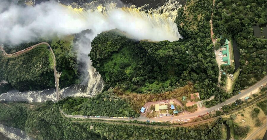
Mosi-oa-Tunya / Victoria Falls (natural, added 1989) ★
Zambia/Zimbabwe [Mosi-oa-Tunya / Victoria Falls - Wikipedia]
On the subject of large objects, Victoria Falls is the largest waterfall on the planet with a total width of 1,708m (5,604ft). However, it neither the widest or highest, its title as 'largest waterfall on earth' is calculated by combining its width and height resulting the world's largest sheet of falling water. To put its size into perspective, it is about twice the height of America's Niagara Falls and well over twice its width.
Our Destinations


Ben Tully
Visual Design & Content Creation
Ben deals with all things design, working on the visual design of our annual guides, Destinations magazine, information leaflets, social media and email campaigns, and much more across the Alan Rogers, Rallies and Worldwide brands. He also produces written content for our blogs alongside our other contributors.
More by Ben TullyRecent Blog Posts
-
Explore the World Your Way
February 13, 2025 -
Guest Post: A Journey through the Parks and Lakes of Western Canada
October 28, 2024 -
Rhythms of the South: Celebrating the Sounds of Southern Soul, Gospel and Funk
October 10, 2024 -
Rhythms of the South: Exploring the Soul of Memphis Blues, Soul and Rock 'n' Roll
October 2, 2024 -
Rhythms of the South: A Journey Through the Jazz and Dixieland Roots of New Orleans
September 24, 2024